
By Eilene Lyon
On a genealogy trip to Belmont and Guernsey counties in Ohio last year, I encountered the National Road when I stopped at the wonderful museum in downtown St. Clairsville. During my travels there and heading west toward home, I enjoyed bits and pieces of this historic corridor that played a role in the lives of my ancestors.
Background

The National Road was constructed from Cumberland, Maryland, to Vandalia, Illinois, in the early 19th century. It was a visionary project conceived by both George Washington and Thomas Jefferson as an all-weather road connecting the eastern seaboard with the interior of the continent.
It holds an unusual distinction: by the time the last section was rolled out, it had become obsolete. But it was also ahead of its time, a precursor to the interstate highways of the future.
George Washington had traveled an early version during the French-Indian Wars, known as Braddock’s Road, leading from the Potomac River to the Ohio River at Fort Duquesne (now Pittsburgh). This road, however, was no more than a rough wagon track. The need for a quality road over the Allegany Mountains was evident even then.
Construction
In 1806, Congress authorized the construction of a national highway, which would connect Baltimore in the east to St. Louis on the Mississippi. Construction began in 1811 in Cumberland, adding onto an existing road (it is also known as the Cumberland Road). It followed Braddock’s to just east of Uniontown, Pennsylvania. Then it headed west to Wheeling, (West) Virginia.
The Ohio portion of the road was not funded until the following decade. Groundbreaking was held on July 4, 1825 in St. Clairsville. Coincidentally, the Erie and Ohio Canal held their groundbreaking ceremony the same day, not far away. Both of these monumental projects would suffer the same fate: being supplanted by the railroads.

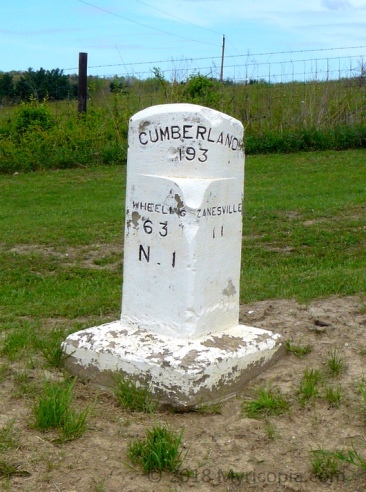
This historic mile marker stands in front of the Belmont County Courthouse to commemorate the July 4, 1825 groundbreaking in St. Clairsville.
Construction continued across Ohio, Indiana, and part of Illinois over the next 16 years, in fits and starts. It was one of the earliest uses in America of macadam technology. Invented by the Scot, John Louden MacAdam, in 1820, the method used layers of small broken stones compacted in a shallow trough and crowned in the center. This surface would shed water, allowing travel in inclement weather. The action of wheels and hooves created stone dust that improved the binding of the material over time.

“1823. First American Macadam Road” Carl Rakeman, 1926. Yes, the rocks were broken by hand and inspected to be sure they were the right size! Imagine the tedium of it.
Along the road, mile markers were placed on the north side. They were different in each state. The Ohio markers are square pillars with rounded tops. They were made of a cement-type material that did not hold up well. The upper portion gave the distance to Cumberland. The east and west sides gave the mileage to the two nearest towns.
The development of mile markers coincided with the rise of the phrase, “Are we there yet?” emanating from small children riding in the back of wagons.
Family Ties to the Road
In 1796, Ebenezer Zane, founder of Wheeling (and my first cousin 7x removed), was given a contract to open a route to Kentucky. At first just a series of blazes, small trees were later removed to make a path wide enough for a horse. Wagons? Fuggedaboudit. Between Wheeling and Zanesville, Ohio, the road followed this old Zane Trace.

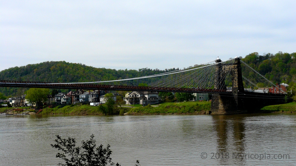
The Wheeling suspension bridge was completed in 1849, ending the use of a ferry to cross the Ohio River. From 1849 to 1851, it was the longest suspension span in the world at 1010 ft (310 m). It is the oldest vehicular suspension bridge still in use in the United States.
Another family connection to the National Road is my 5th great-uncle, Humphrey Anderson. In 1830, Humphrey was working as a contractor on the project somewhere between Zanesville and Columbus. He caught typhoid fever in August. His wife, Lavina, attempted to reach him from their home in Guernsey County, but he died before she arrived. He was buried alongside the pike.
Many of my ancestors and their families traveled the road when they migrated from Belmont County to eastern Indiana. Records suggest that there was travel both ways as family members went home to see relatives, or the Ohio branch came west for visits.
Life Along the Road
Between 1830 and 1850, the economic impact of the National Road was enormous. Finally, farmers in the Old Northwest Territory had easy access to markets for their products. In eastern Ohio, the road went through existing towns, but as it moved westward, “Pike Towns” sprang to life as the road came through.
The National Road became Main Street, where the business and residential development occurred. To the north and south were parallel backstreets with simple lodging for drovers and pens for their livestock.
Taverns were built roughly every ten miles, a normal day’s travel by wagon or foot (i.e. the drovers). East of Zanesville, it is supposed there were two taverns per mile of road. These were social hubs and people gathered to relate tales of the road as they relaxed in the evening after their travels.
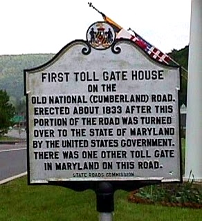
Though the pike had been built with federal funds, the various sections were turned over to the states to maintain. In order to pay for upkeep, the states established toll houses. This schedule of Toll rates gives you an idea of the type of traffic one would encounter. Note that wagons with wheels wider than eight inches were free – they were thought to be helping compact the road surface, so their passage was a benefit.
Disuse and Revival
After 1850, as railroads became the long-distance transport of choice, the National Road fell into disuse. It’s first revival occurred in the 1890s when bicycling became popular. It wasn’t until the automobile’s rise in the 20th century that the National Road was truly reborn. It became U.S. 40, though it was rerouted in some places, and made straighter in others. Now it is largely overshadowed by I-70.
But there are places where you can still follow the course of the original road. And even some spots where you can see earlier incarnations. Many bridges from the early 19th century remain. Some of the taverns still exist and a few are run as inns. It’s fun to look for the old mile markers as you drive along. There are many historic sites and museums to see as well.

A section of the old National Road in eastern Ohio showing two improvements. In 1918, during WWI, the federal government paved 75 miles in brick to improve military transportation. Asphalt was a later addition to the road surface.
The National Road was a major undertaking in the opening of the continent to settlement and development. It’s almost certain my family used it to relocate from Ohio to Indiana. How many of your ancestors traveled this historic route? How far did they go?
Sources:
Harper, Glenn and Doug Smith. 2010. A Traveler’s Guide to The Historic National Road in Ohio: The Road That Helped Build America. 4th ed. Ohio National Road Association, Springfield, Ohio.
https://en.wikipedia.org/wiki/National_Road
https://en.wikipedia.org/wiki/Macadam
https://en.wikipedia.org/wiki/Wheeling_Suspension_Bridge
http://www.genealogy.com/ftm/m/c/l/Larry-L-Mclaughlin-1/WEBSITE-0001/UHP-0191.html
https://www.nps.gov/fone/learn/education/classrooms/tnr-unit9.htm

Wow that’s fascinating! Great post!
LikeLiked by 1 person
It’s always fun to find a family connection to history. I wonder how many things have that obsolete/ahead of its time dichotomy?
LikeLiked by 1 person
Oh gosh I’m sure the possibilities are endless!
LikeLiked by 1 person
How interesting and nostalgic. Thanks
LikeLiked by 1 person
Thanks for reading, as always!
LikeLike
I am amazed at the elegance of the Wheeling suspension bridge.
LikeLiked by 1 person
I hadn’t realized the significance of it while I was there but really thought it attractive, which is why I took the picture.
LikeLike
Fascinating post, you write very well. “Tar macadam” was a phrase I grew up with, I had no idea of its origin. I once owned a small house on the outskirts of Dublin, there was a pub nearby that was originally a tavern or coach house and still had a tavern license which meant it could stay open all night long; to my friends at the time, the absence of closing time was an irresistible attraction.
LikeLiked by 1 person
Thanks for the kind words! Glad you enjoyed it. I would love to check out the pub scene in Ireland sometime.
LikeLiked by 1 person
I’ve never heard of the National Road before. How cool that you have a connection to it!
LikeLike
Eilene, you are so knowledgeable. Amazing to me and of course another great post with personal ties.
LikeLiked by 1 person
Delighted to have you visit!
LikeLiked by 1 person
When I was a child growing up in Ohio old-timers would refer to the National Road with pride. It was a big part of their childhood narratives. I remember when I finally saw parts of the National Road, near Springfield OH, I was underwhelmed.
LikeLiked by 1 person
It’s less impressive than the gravel county roads we have here, but when you realize how the NR was built, it gives you pause.
LikeLiked by 1 person
A historical gem that I had never heard of.
LikeLiked by 1 person
For some reason, I hadn’t either!
LikeLike