By Eilene Lyon
Our mountain biking trip this week took us to Old Lime Creek Road in the San Juan Mountains. It follows an ancient Ute Indian path that became a mining road, and later the route between the Animas Valley and Silverton. The Civilian Conservation Corps made improvements in the 1930s, but it was supplanted by the current highway alignment, which runs over Coal Bank Pass.
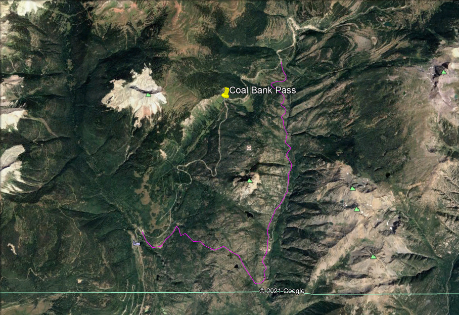
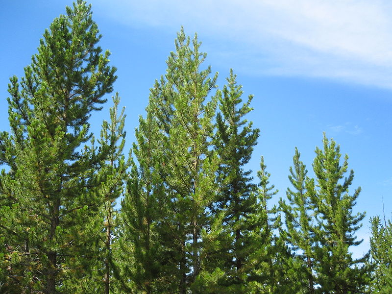
The ride can be done with a shuttle, starting at the north end, by driving over Coal Bank. On the northeast side of the pass, you can stop at an overlook to see the 1879 Lime Creek Burn. Reforestation began in 1911 and this is the only place you will find lodgepole pine in the San Juans – it isn’t native to these mountains.
Alternately, you can do an out-and-back ride, starting from the south end at Cascade Creek. We chose to shuttle and do the 11-mile ride from the north. Many websites will tell you that this road is in good condition and mostly drivable in a passenger car. Don’t believe them!

Back in the 1980s, I drove many of the mountain back roads in my Honda Accord, including this one. It seems that around 2002, the year of the Missionary Ridge Fire (GW’s first term), that Forest Service funding for road maintenance vanished.
Very few get graded anymore and the deterioration over the past two decades is obvious to locals. The increasing popularity of ATVs and backcountry travel has taken a toll as well. Even in our four-wheel-drive pickup, some roads make for downright unpleasant traveling.
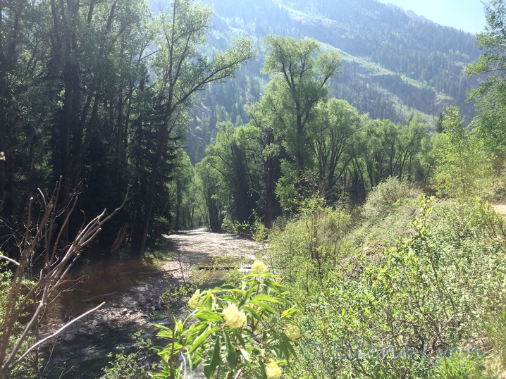
The bike ride begins with a steady downhill to Lime Creek, though much slower than you would expect due to rocks jutting everywhere. You pass a couple side-stream waterfalls before reaching the main creek: a cottonwood-shaded, clearwater stream. There is a roomy disbursed camping area (free!) and good fishing.
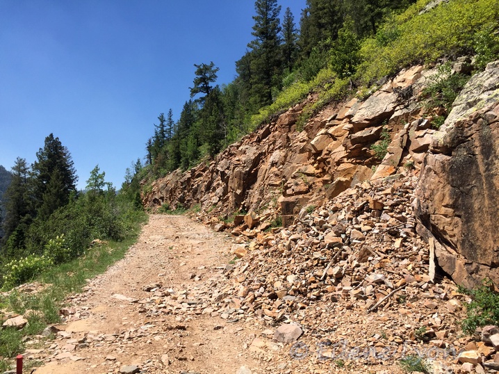
Beyond this point, the road narrows more and begins winding up a ledge through the canyon. Twilight Peak looms to the east. A solid rock wall forms the road’s western barrier, with a steep drop to the creek on the other side. Columbines, elderberry, and asters bloom among tumbles of scree on the roadside.
As you approach the top of the climb, you’ll find stone guardrails built by the CCC and impressive views.
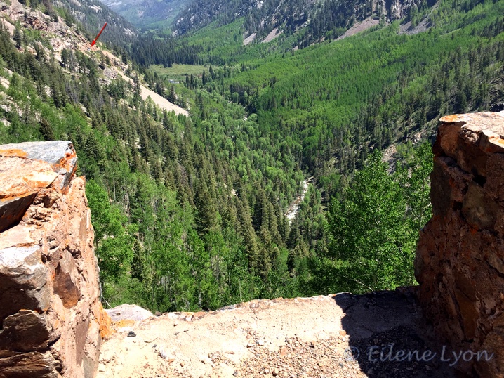
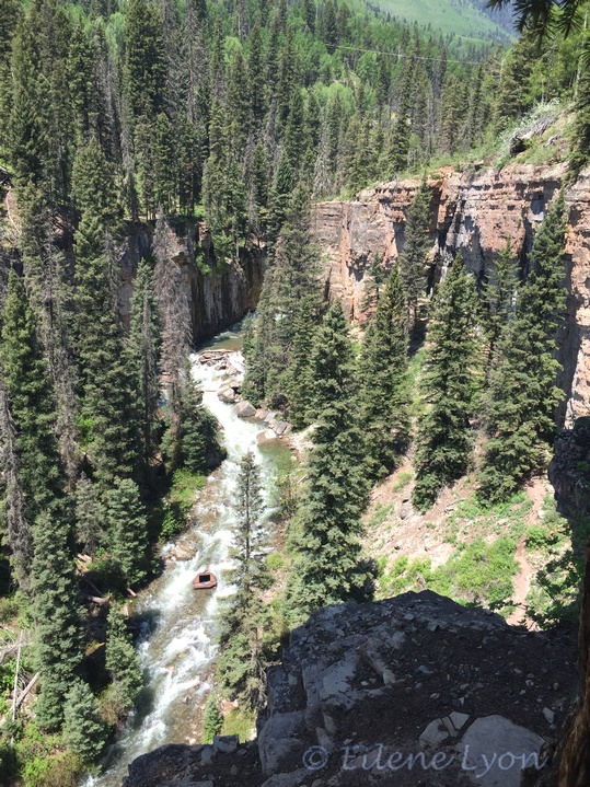
If you look at the upper-left corner of the photo above (red arrow), you can see a vehicle on the road. It hasn’t moved in several days, because…
(Please. Please. Please. Don’t be this guy.)
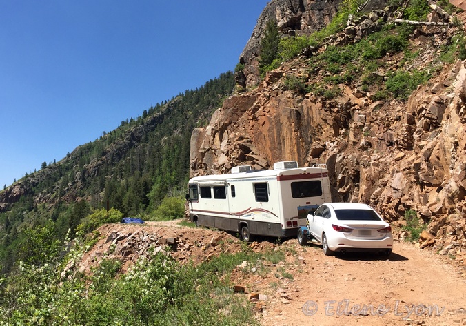
I cannot imagine why someone would take a rig like this off the pavement or onto anything but the best gravel road. I realize I’m not being very kind by making fun of his self-created predicament. Certainly we have been victims of our own blunders a time or two.
But hundreds of thousands of tourists roam the San Juans every year, and too many are injured or even killed because they don’t take the risks seriously, even on the paved roads.
If you see a sign like this one…
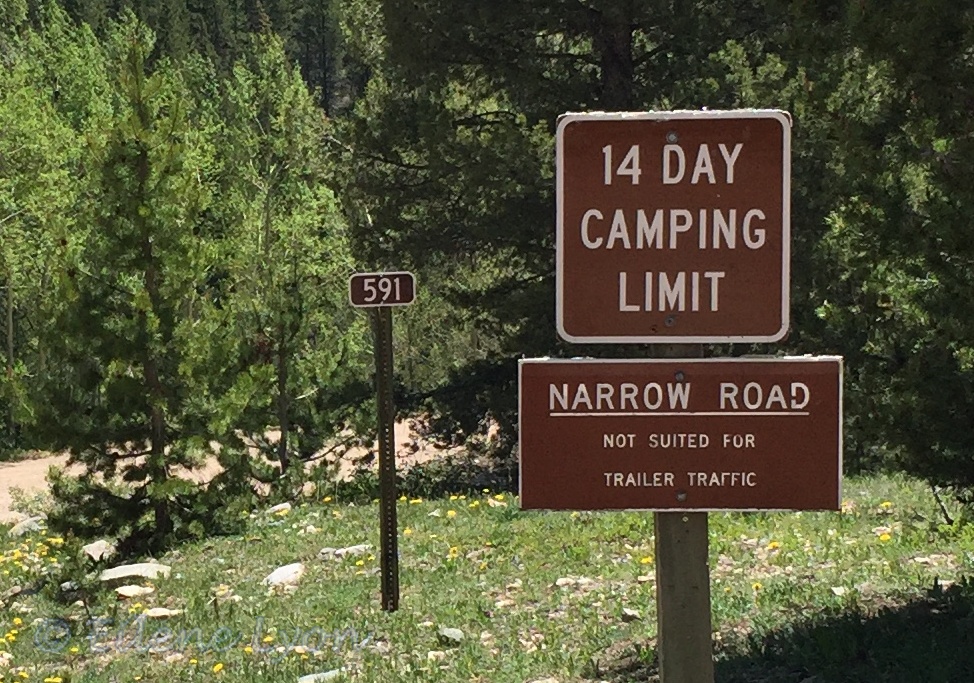
Or one that says “High clearance and 4 x 4 vehicles recommended” — do take them seriously. Do not take your Class A motorhome with tow-behind on these roads. Do not bypass the open area that will enable you to turn around and go back the way you came, awful as it must have been.
Do not proceed past this rock slide, then into tight turns you can’t negotiate. Because then you might come to an immovable object like this boulder or a fallen tree.
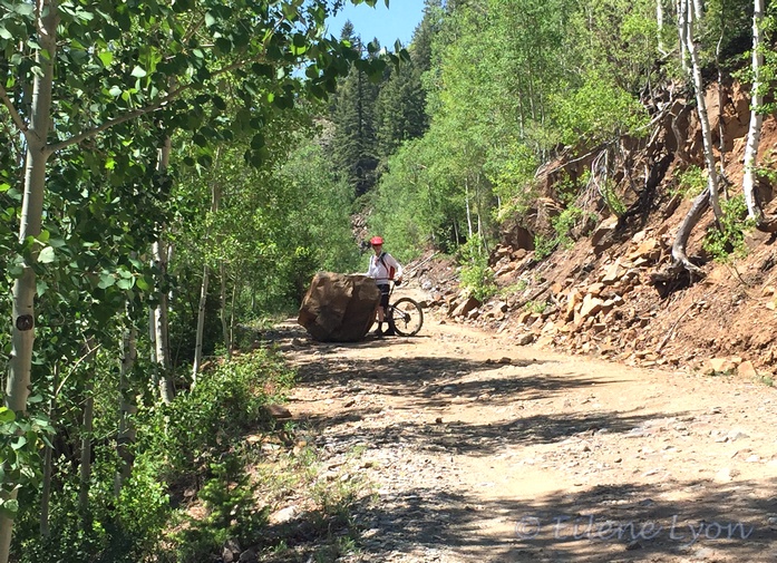
You can’t move forward and you better be darn comfortable driving in reverse on a ledge for a very long distance. ‘Nuf said.
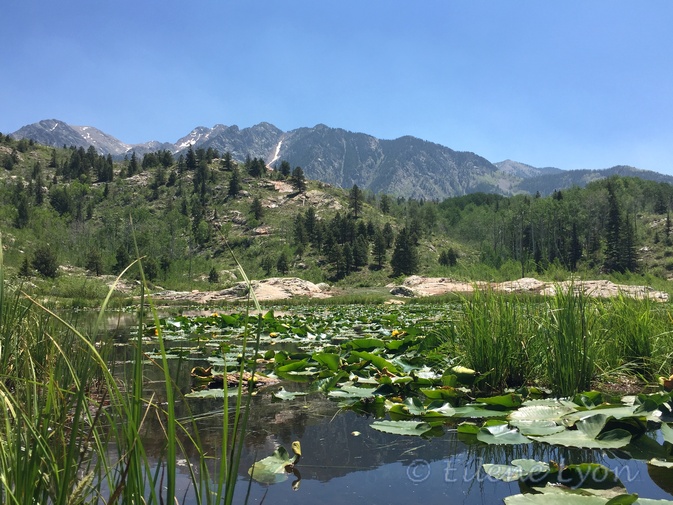
After completing your climb out of the canyon, you pedal through aspens, pine, and spruce to where beavers create pretty wetland ponds below Spud Lake. (The official USGS name for the peak above — not shown here — is actually Potato Hill.)
Beyond the beaver ponds is a semi-gentle downhill ride back to the drop vehicle at the highway, with the road gradually improving as it passes through an area of private residences. Beyond an open meadow with dispersed camp sites, is the Cascade Creek Canyon.
Time to drive back over Coal Bank to get the bike-hauling vehicle and enjoy the beautiful trip back to Durango, or over Molas Pass for lunch in historic Silverton.
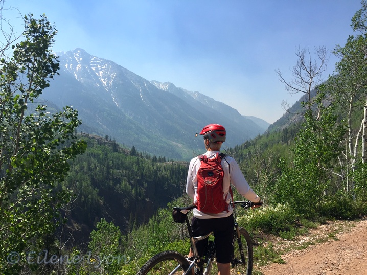
Feature image: The Putterer on Old Lime Creek Road with Twilight Peak to the left. The air was filled with smoke from regional wildfires in the morning, but mostly cleared up by midday.
P.S. In case you want to learn more about just how treacherous San Juan Mountain roads can be, check out this article. I warn you not to watch the video if you’re at all squeamish — it’s terrifying.
https://www.durangoherald.com/articles/video-footage-captures-jeep-falling-off-black-bear-pass/

The scenery is gorgeous. But wow, that all sounds scary (at least for driving).
I was trying to figure out what you meant by shuttle. I assume it means you took two cars, parked one at each end? Or is there actually a service that shuttles you back to your car?
LikeLiked by 1 person
Yes, we took two vehicles. Lime Creek is not even close to as scary as Black Bear or many other roads, but the section with the stone walls would certainly bother some people. I know some people who aren’t comfortable even on the highway through these mountains, particularly on Red Mountain Pass. It’s just important to have the right vehicle.
LikeLiked by 2 people
I will just sit back and enjoy your photographs instead!
LikeLiked by 3 people
My husband says I’ve created an excellent anti-tourism piece for Southwest Colorado. Me: “I’m good with that!”
LikeLiked by 1 person
BEAUTIFUL And thanks for the memories. The CCC, WPA and other programs are things that Joe Biden should bring back, It could make thoughtful Americans out some of those “lost people” who think that the government does not do enough for them. Jobs, nature, conservation, healthful outdoors, history of our past good and bad, and appreciation for the most beautiful country in the world. Maybe Joe should look at all the things that Roosevelt did to pull us out of the same bad times when a terrible government did the same things that the Trump gang has done~!
A very small tax on those “Fat Cats” would pay for the whole thing and they would still be very rich~!!!
In the meantime a POX on McConnell who is singlehanded destroying our Democracy~!
LikeLike
Glad you enjoyed the piece. Those programs really produced some excellent and long-lasting work.
LikeLike
Thanks for the great descriptions of old lime Creek Road. We’ve been there many times and you’re right about the road continuing to deteriorate. Can’t imagine why anyone would think it was a good idea to take a rig like that on that road. Even if they turned off the highway with it the first quarter mile should’ve been enough to cause them to turn around.
LikeLiked by 1 person
I know! The fact he went beyond the camping area where he could turn around – and even that he got that far in the first place – just baffles me completely. He seemed to think it was the government’s fault and he’s still waiting for them to come get him!
LikeLiked by 1 person
I’m going to have nightmares about the RV
LikeLiked by 1 person
He’s found a campsite with a great view for the summer. But not being level, he might have some plumbing issues and also roll out of bed.😆
LikeLiked by 1 person
😂😂😂
LikeLiked by 1 person
Incredible that the woman and dogs survived that accident. Some people refuse to take risks seriously and seem convinced that bad things only happen to someone else. I guess that’s why we have the Darwin Awards!
LikeLiked by 1 person
That is incredible. I hope she is doing okay now. I’m skeptical the guy actually set the emergency brake. I’ve become a lot less adventurous over the years, realizing that some risks are just not worth it to me.
LikeLike
I so enjoyed this rugged adventure in the San Juan Mountains, Eilene. I appreciated the link, too. Your photos were incredible, and the narrative pleasant too. It’s true we all make blunders from time to time, but this RVer really got into a doozy. Intriguing and exciting post.
LikeLiked by 1 person
Thank you, Jet. I realize this sort of outing isn’t everyone’s cup o’ tea, but we really enjoyed our ride. I don’t normally try writing in 2nd person, but I thought it worked as a sort of tour-guidey thing.
LikeLiked by 1 person
Great blog! I live in the Colorado mountains and I don’t travel roads that I think I’d have trouble with. No idea what the RV people were thinking. It looks beautiful there. I may have to take a trip.
LikeLiked by 1 person
Thanks! It is beautiful here. What part of the state do you live in?
LikeLike
I live in Coal Creek Canyon, South of Boulder Canyon, West of Denver. Been in the Denver area most of my life, up here for about 27 years. So much of this state I still haven’t seen!
LikeLiked by 1 person
I can say the same, though I certainly have covered a great deal of it. Always amazing how much there is still to see.
LikeLike
I got palpitations when I got to the bit about the RV. And having looked at the url of the video, there is no way I am going to open it! What were they thinking? And how will they ever get it down?
LikeLiked by 1 person
I can’t really fathom why that guy even started down that road, much less that he went as far as he did – probably five miles. I also have no clue how to retrieve that vehicle. He can leave in his car, if he wants to. However they get the motorhome out of there, it’s going to cost beaucoup bucks!!
You could read the article, but it does have photo stills of the video, so if it gives you the willies, you don’t want to go there. Even if you don’t watch the jeep falling, the video is from another jeep’s dash-cam and the first few minutes give an excellent idea of what it’s like to drive on Black Bear Pass. Even that is not for the faint-of-heart.
LikeLike
I still think I’ll pass! Seems to me the only way they could get that vehicle out is in bits!
LikeLiked by 1 person
That would be hilarious! We got the impression he had recently bought the car and the used RV. Even if he’s had it a while, I doubt that idea would go over too well.
LikeLiked by 1 person
The scenery is gorgeous, but there is no way I would take a vehicle on those roads. They look more suited to mules.
LikeLiked by 1 person
That’s funny, I almost added a photo of the horses and mules in the corral by the Cascade Creek Canyon. But really, this road is drivable, but not with big RVs. I’d feel sorry for the mule walking on all those rocks.🙂
LikeLiked by 1 person
Oh, that is funny!
LikeLiked by 1 person
Holy. Cow. This made me nervous just looking at that road and that RV. Gorgeous scenery though! Looks fun!
LikeLiked by 1 person
It was a great place for a bike ride, though not a smooth one.
LikeLiked by 1 person
Firstly Eilene, breathtaking captures here.
As for all the risks these tourists take? I just don’t get it. I guess they let their adventurous side come out to play without thinking about the consequences. Which, I relate to . . unless one of the consequences happens to be death.
Yeah, when the GPS tells you “Nuh uh . . .” Listen!
LikeLiked by 1 person
Thanks. It was a beautiful day to be out and about in the mountains (well it almost always is).
I don’t know what drives some of the riskiest behaviors. Adrenaline junkies, I suppose. Then there’s just sheer stupidity in some cases.
LikeLiked by 1 person
I was going to say, being up in the mountains . . always a good thing.
Either meeting or . . .
LikeLiked by 1 person
Gorgeous photos. I feel calm looking at them but I know if I was biking I’d be more focused on not falling off my bike than seeing the beauty. I’m glad you had a good time of it and I also wonder about the wisdom of driving a RV with a sedan in tow on these roads. What were they thinking?
LikeLiked by 1 person
When we got to the starting point, there were a couple people parked there looking for some waterfall I’d never heard of. They had walked a quarter mile down the road and said “No way are we taking our cars down that!” You’d think someone with an RV AND a car would have done something similar. I do that a lot when we’re camping: get out of the vehicle and get walking. I need to know that if I drive in, I can drive out.
LikeLiked by 1 person
What a great trip this would be and I am envious. I have to admit that as photogenic as that picture was, I’d be afraid I’d get woozy looking down below at it and that would make me nervous, even though I’m not afraid of heights. The crumbling road in spots would have been worrisome enough, without taking a rig like that around those curves – yikes! I’m surprised there weren’t signs along the way stating “dangerous curves ahead – vehicles limited to no longer than ______ feet.” When visiting North Carolina, I drove through the Great Smoky Mountains many years ago. It was my first time driving on such hairpin turns and my heart was in my mouth a good part of the journey. 🙂
LikeLiked by 1 person
It is a nice scenic road – with the appropriate vehicle. Honestly, I can’t imagine most RV owners would just blindly go down a narrow, rocky road like this one. It boggles my mind. There is a warning sign, but this guy was oblivious to it and to what he was driving on, apparently. I’m astonished he got as far as he did.
LikeLiked by 1 person
On such rigorous terrain, given the length of that rig, I’d have been tempted to park it and take a hike up ahead to scope it out.
LikeLiked by 1 person
You’re referring to what a sensible person would do! This guy was having none of that sensible nonsense.
LikeLiked by 1 person
Really? Oh MY Goodness, what an interesting fact. Just looking at that bus picture threw me into panic mode. Why would people ever sign up for an experience like that.
LikeLiked by 1 person
Oh, that guy and his motorhome just made a BIG mistake. He was stuck there for a week, but has since been rescued. Made the front page of the local paper. (I scooped them with this blog, though)😉
LikeLike
Spud Lake and Potato Hill are absolutely adorable names. That road looks anything but though. I’ve gotten so nervous (and carsick) every time I’ve had to ride along a winding mountain road – I can’t imagine just completely ignoring the signs!
LikeLiked by 1 person
Yeah, not exactly that guy’s most brilliant moment. We all have them, but hopefully the consequences are not dire.
LikeLiked by 1 person