
By Eilene Lyon
This information will be useful for any genealogist or family historian who deals with old land records in the eastern U.S. where surveys were done using metes-and-bounds, rather than the federal land survey grid (township and range).
Metes-and-bounds surveys are usually irregularly shaped and often delineated by trees, streams, and other natural features, instead of nice, neat 90-degree corners marked with permanent survey markers.
Because the ancestors of Elias D. Pierce, who I’m researching, were early settlers in what is now West Virginia, all the properties are described this way. I’ve found a free online tool that can draw the property boundaries from survey or deed descriptions. The trick is being able to pinpoint at least one corner. Unfortunately, that can require searching through many records until you can compile a list of adjacent landowners with at least one of the parcels having a lasting geographic monument.

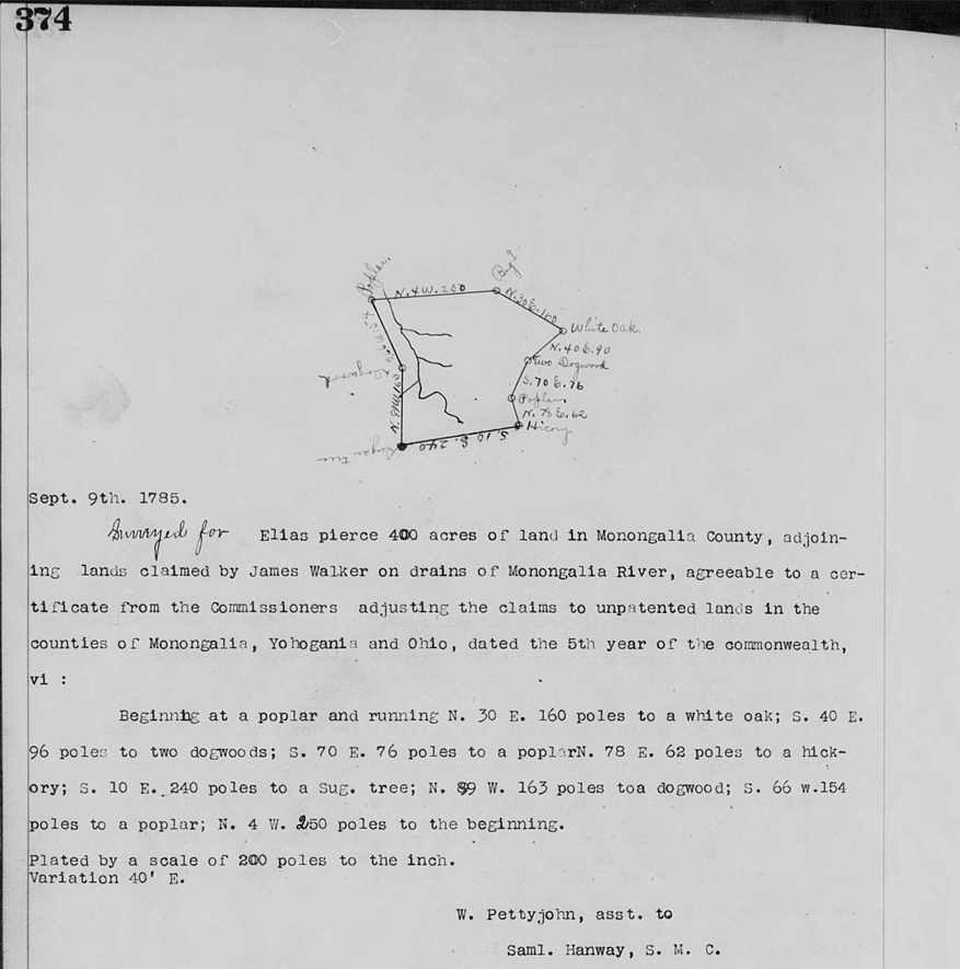
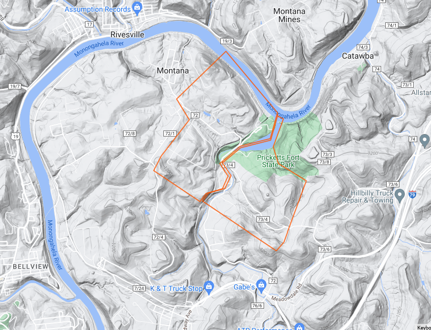
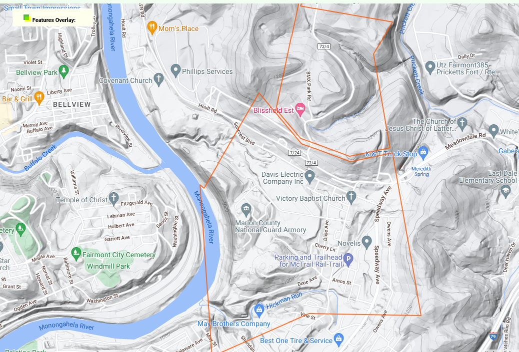
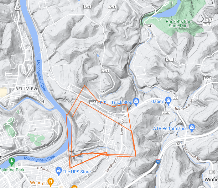
For example, the area I am working on is bounded by a bend in the Monongahela River in Monongalia County, West Virginia, opposite the town of Rivesville. There is a notable landmark here called Pricketts Fort. Pricketts Creek runs by the fort before emptying into the Monongahela. I made an earlier effort to figure out where Elias Pearce (grandfather of Elias D. Pierce) had his land, but I was off by a bit.
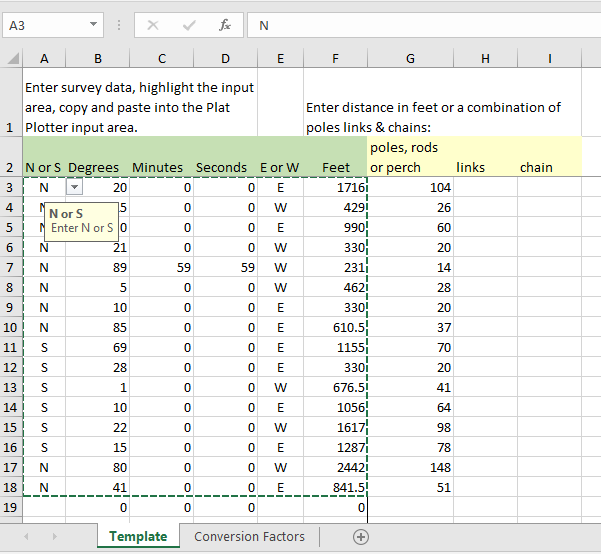
Two of the properties I’ve researched have a starting corner at the mouth of Pricketts Creek. That enabled me to use Plat Plotter to accurately put them on a map. Plat Plotter provides a downloadable Excel spreadsheet for entering survey data. This must be done very carefully! If I have a survey map, I double check the lines with the verbal description—there are occasionally transcription errors. Having taken a surveying class, I can sketch what the polygon should look like if I do not have an image to work from.

On the Plat Plotter webpage, first move the flag to the general area you will be working in. Keep zooming in and adjusting the flag as needed. (I discovered that if you zoom in first, you will not be able to find the flag, which is sitting somewhere in Oklahoma.) This flag is what you will place at your starting corner.

Copy and paste the survey information from Excel into the box provided, give the plat a name, and click on “Enter Survey.”
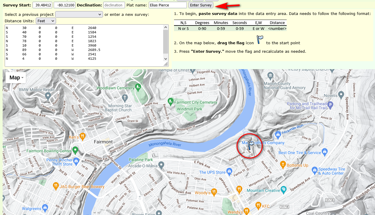
If your polygon looks wonky (like a bowtie, perhaps), you may have an error in your survey data. If you wish to move the polygon, first move the flag and then click “Recalculate.” If you log in using a Google account, all your work will be saved and you can go back and edit and work with each survey plat.
I confess that I can spend endless hours playing around with these plats, trying to fit them together like a jigsaw puzzle. There may be a “Big Book” of surveys (I’ve seen references to it) that shows all the plats laid out together, but I’ve yet to locate it. In the meantime, Plat Plotter is the best tool I have.

Why go to all this trouble? Well, I’m writing about a group of associated people and I want to know where they lived, and how their properties lay in relation to one another. This can help me bolster my case for marriages between particular families living in proximity to one another, when there is no marriage record, for example. It also gives me some idea about the terrain and environment.
I warn you, if you are working with eastern-state surveys in your research, you may find Plat Plotter a rather addictive pastime.
Feature image: Buildings in the reconstruction of Pricketts Fort on the Monongahela River at Pricketts Creek, (Wikimedia Commons)

Wow! This is amazing. I may never have need for this as I live in Australia and don’t think my ancestors owned much land in the early settlents but it is fascinating, just the same.
LikeLiked by 1 person
It’s a pretty cool tool! I just wish more of these surveys had some sort of permanent landmark to go by.
LikeLike
Very impressive! I’ve never done any of this kind of work since most of my American ancestors lived in cities and weren’t landowners. But you never know.
LikeLiked by 1 person
If it weren’t for this research project, I might not have needed it, either. Most of my land-owning ancestors lived in the federal land survey states and got homestead land.
LikeLiked by 1 person
This is fascinating, Eilene. The things we learn in the blogosphere! I love that you have learnt how to do this to better situate yourself and the people you write about. Can’t accuse you of winging it!
LikeLiked by 1 person
Right! You just never know what sort of things will turn up in the blogosphere. I’ve learned many new things this way.
LikeLiked by 1 person
Absolutely. I love this 🙂
LikeLiked by 1 person
🙂
LikeLiked by 1 person
I am so impressed Eilene, truly. The time involved in learning this skill and that you share it with others. Researcher and teacher- I applaud you 🙂
LikeLiked by 1 person
Thank you, Deb. I know there are family researchers out there who read my blog and thought some might want to know about this. Since it took some trial and error to figure out how to use it, thought a tutorial would be helpful.
LikeLiked by 1 person
How interesting. The things you uncover!
LikeLiked by 1 person
I was giving a talk about using deeds and maps in genealogy research and had this website in my bookmarks, so I took the time to learn to use it and found it perfect for this project.
LikeLiked by 1 person
Well, this explains why my mother and I were never able to locate the old homestead in Candia from the 1849 deed!
LikeLiked by 1 person
It can be nearly impossible!
LikeLiked by 1 person
Now I don’t feel so bad at not being able to find the place!
LikeLiked by 1 person
They really didn’t create a lasting kind of documentation—so no, no reason to feel bad!
LikeLiked by 1 person
Whew!
LikeLiked by 1 person
Well, I probably won’t ever have need for this tool, but it’s always fascinating to learn something new!
LikeLiked by 1 person
It was a new thing for me that I didn’t know I needed!
LikeLiked by 1 person
Don’t you love those unexpected gifts that come into your life!?
LikeLiked by 1 person
Absolutely! It has happened many times and it feels special.
LikeLiked by 1 person
That looks like a cool tool. I should see if there’s something similar for Albert, where my husband’s great-grandfather settled after the Boer War, when the government granted war veterans with pieces of land. I do have some of the documents from Library and Archives Canada, but this kind of plotting would be fun too, to understand exactly where the property was.
LikeLiked by 1 person
Because it’s based on Google Maps, I suspect it can be used anywhere on earth.
LikeLiked by 1 person
I’ll have to give it a try!!
LikeLiked by 1 person
Let me know how it goes!
LikeLike
I think describing this painstaking (yet enjoyable for you) rolling-up-your-sleeves-and-digging-in-project as a jigsaw puzzle was a perfect choice of words. I have heard of metes and bounds and am wondering why and you know I’ve not been working on my family tree.
LikeLiked by 1 person
I can’t guess where you’ve come across the term, of course. I can certainly while away hours pursuing this, but then wonder if maybe there are better ways to use my time!
LikeLike
Eilene, I can’t imagine hearing my grandmother talking about her parents’ farm – but I have heard the expression. It does not matter how you while away the hours if it makes you happy. I often sit down to write a blog post and by the time I’ve compiled the photos, written the narrative and finalized the post I am aghast how long it took me, but lucky for me I live alone, so I can work at my own pace and no one is clamoring for my attention. 🙂
LikeLiked by 1 person
Oh a blog seems to always take me an entire day or more! I can appreciate the time it takes, especially with photos involved.
LikeLiked by 1 person
I had no idea what all blogging entailed Eilene. My good friend/neighbor urged me to start a blog and because we were close, I did it for her. If I tell people I am a blogger (to suggest sometimes why I am behind in e-mail correspondence and often everything else), they look at me as if to question why I say that. But I still enjoy every minute of it.
LikeLiked by 1 person
Me, too! I can understand non-bloggers don’t really get it, though. I do wish more of my friends would read my blog instead of expecting me to put something on Facebook.
LikeLiked by 1 person
I had a few friends sign up but they never comment on my blog, so they likely delete it, direct it to SPAM or signed up with an old e-mail address to be polite, as they are all still subscribed. People and Facebook … I mentioned before I’m only on there for news, nature and nature photography sites and parks where I frequent as I don’t go to those places if they have events planned. Summer in Michigan is all about festivals and it seems there is one every weekend. I have a friend who must report her every move and meal on Facebook. I turned off friends’ posts and just check what they’re doing every so often.
LikeLiked by 1 person
I certainly wouldn’t do any more than that.
LikeLiked by 1 person
Wow learnt something new and very interesting write up
LikeLiked by 1 person
Thank you!
LikeLike
Now THAT is what I call attention to detail.
LikeLiked by 1 person
Sometimes I’m astonished by finding records dating to the 1700s that can help me piece together a story.
LikeLiked by 1 person
That’s remarkable actually.
LikeLiked by 1 person
Land, yes, marriage records, no, unfortunately. Sigh.
LikeLiked by 1 person
I knew nothing about any of this and admire how much effort you put into your research, not to mention explaining this to the rest of us. It’s fascinating what you can learn when you go looking for it.
LikeLiked by 1 person
How cool. I’m from “back east” and have 100s of land records in metes and bounds. I have an app on my phone I can enter the data. It generates the shape, assuming I can read the handwriting.
LikeLiked by 1 person
Yeah, getting the shape is half the battle. Finding out where it goes in the map is really a challenge!
LikeLiked by 1 person
I have been using Plat Plotter for many years now.
I have not used the Excel format for inputting data as it gets a little too “point and clicky” for me.
I use a simple Word Pad to type in the metes and bounds from the deed…
N 50 32 w 50
s 48 15 e 74.3
and so forth…then just copy and paste those calls from the word pad into the “Enter Survey” white box – the North, South, East West are not case sensitive
Plat Plotter is an incredibly powerful tool, however I and many folks in the past few years have had a “500 Internal Server Error” issue and have lost access to our plats (I had well over 200) and the author of the app has not responded to the User Forum for a few years. Fortunately the error only occurs based on the email address you sign in under…I have other email addresses that I use and those are not affected – yet.
Also, Chrome or Internet Explorer/Edge does not appear to work with the app anymore, but I can still use it with Firefox
Hope this helps!
Vern
LikeLike
Hi Vernon,
Thanks for your input. I’ve learned that there are other mapping tools out there for metes-and-bounds, but I have not looked at them yet. I do use Firefox, so the browser hasn’t been an issue, yet. I do want to explore other options sometime soon. Let me know if you find one you like!
LikeLike
Hi Eilene
I did find a workaround – of sorts
I’ve noticed that the Metes and Bounds tool still works on my iPad! I have not tried it on my Mac yet.
My Firefox stopped working a while back, but I found that if I rolled back my version of Firefox to an older version – it works on my PC again. Of course that leaves your computer vulnerable.
LikeLiked by 1 person
Thanks for the update!
LikeLike