
By Eilene Lyon
After our visit to Rifle Falls State Park, we spent the next five days taking scenic routes from Colorado to Canada. We drove through Meeker (been there before) and stopped in Craig to fill our propane and get a Montana gazetteer (because detailed paper maps are the best!). Then we headed to the far northwest corner of Colorado, where it abuts Utah and Wyoming.
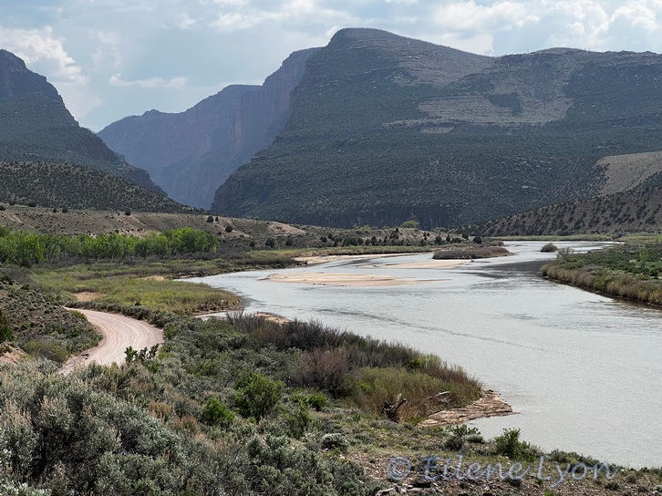
This remote, sheltered valley is known as Browns Park. The first whites to visit and overwinter were fur trappers in the 1830s. This was one of the last areas of Colorado to receive homesteaders, when the Utes were removed from the area to a reservation in Utah in 1881. It was a favorite hide-out for outlaws since they could quickly move between the three states. We stopped to view the Gates of Lodore, the entrance to a canyon of the Green River in Dinosaur National Monument.
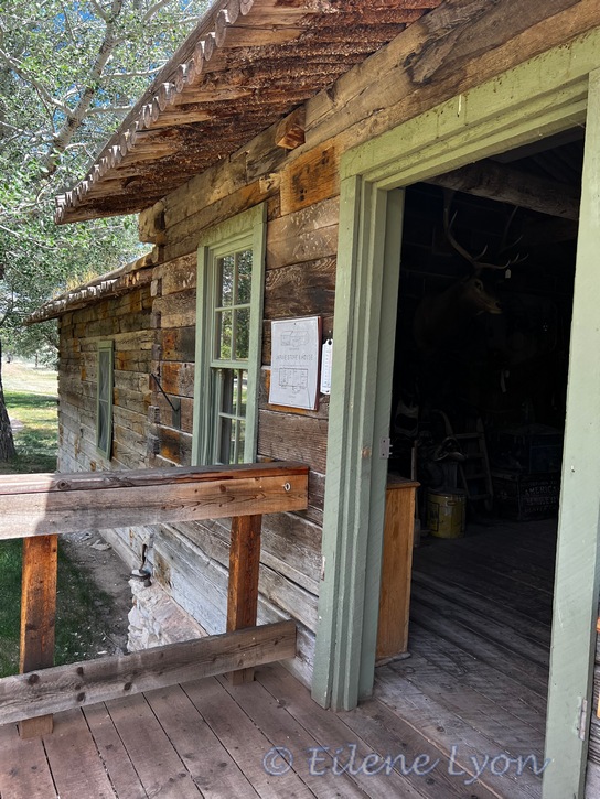
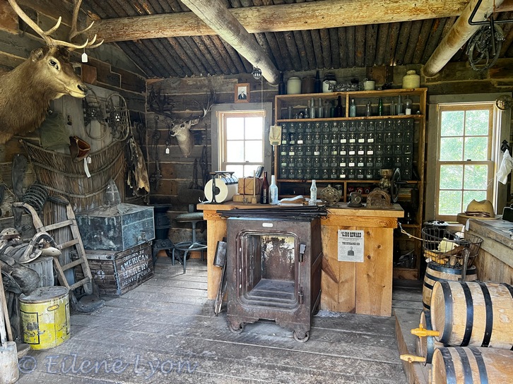
From there, we made a stop on the Utah side of Browns Park to see the John Jarvie ranch. Jarvie was a Scottish immigrant to Rock Springs, Wyoming, where he kept a saloon. After his marriage, he and his wife settled along the Green River where they opened a trading post serving a radius of 75 miles.
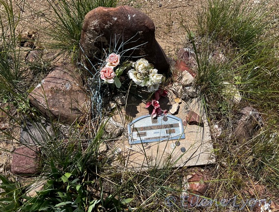
Jarvie’s wife Nellie died at a young age of tuberculosis, so Jarvie taught his four sons mathematics, music, and many other subjects. His home was always open to travelers, but one day the wrong sort stopped by. Jarvie was murdered by thieves in 1909 and is buried in the Lodore Cemetery on the Colorado side of the park. You can read his story in my book, What Lies Beneath Colorado.
Leaving Jarvie’s place, we continued northwest, driving through Utah and the last 8 miles in Wyoming to US 191. This section of road was horrible washboard! I tried driving slow, but it was intolerable, so I sped up and “floated” our heavy van over the ridges, hoping not to wind up in a ditch.
Finding no good remote camp site along this stretch of US 191, we spent the night at the huge county fairgrounds campground in Rock Springs. When there are no events (as then), the place is practically deserted, and well away from the freeway noise. It had wonderful restrooms and full hook-ups for just $30 a night, a bargain.
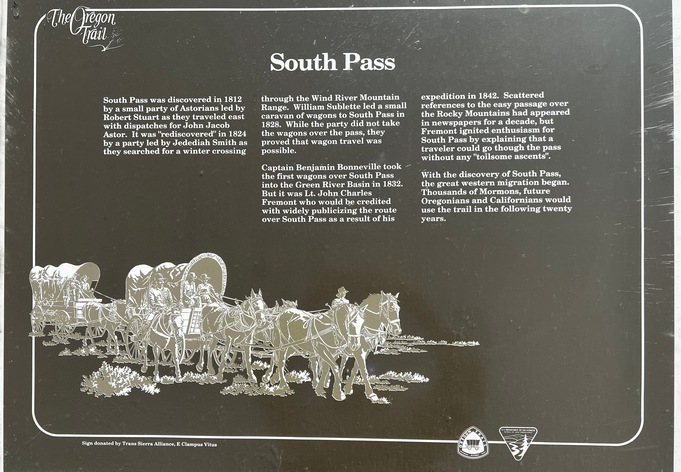
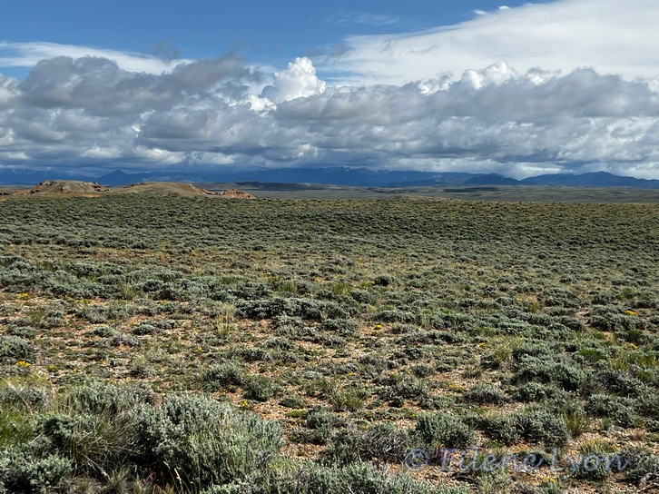
The next day we drove the route over South Pass, which hardly rises above the surrounding terrain. This was where the Oregon and California Trail migrants crossed the Continental Divide. Though not terribly higher in altitude than where we live, it was quite chilly and windy up there.
Our route took us to Cody, east of Yellowstone (been there, done that), then we drove north on the Chief Joseph Scenic Byway (WY 296) and crossed a divide at Dead Indian Point and camped below at the Dead Indian Forest Service campground. The grim name is a reminder of the 1877 Nez Perce War and their flight away from the U.S. Army toward Canada. It’s believed the route Chief Joseph took with his people went east from where we camped. We did a gorgeous hike in the area the next morning.


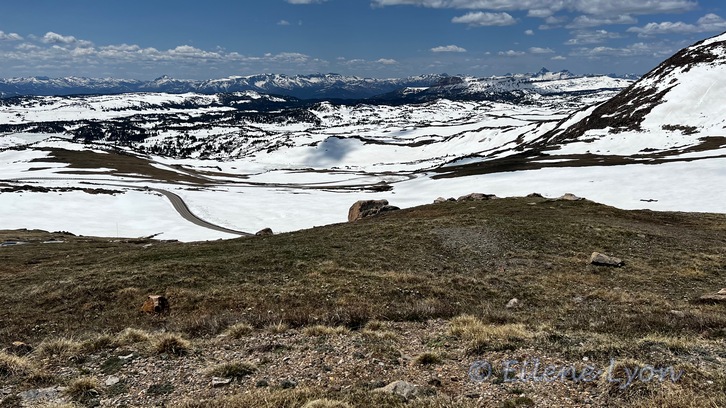
The next amazing scenic route was US 212, which includes a section that summits Beartooth Pass at 10,947 ft. Plenty of snow remained–and people to ski on it, too. There is even a chair lift running up there. Skiers park at the TOP of the lift and ski down. Some skiers simply hiked the area peaks. This highway drops down into Red Lodge, Montana. Certainly one of the more spectacular drives in the entire country.
We continued on to an RV park in Big Timber, Montana, and had a very nice breakfast at a local restaurant in the morning. We drove a short section of I-90, then took US 89 up to Great Falls.
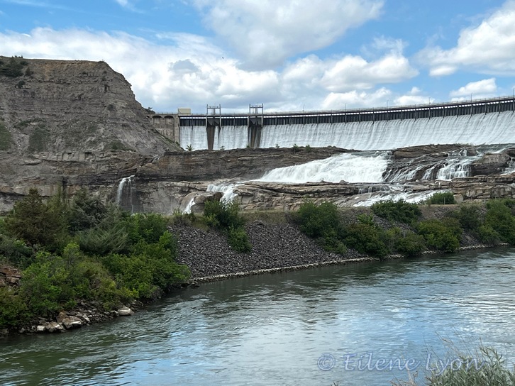
Seeing the falls was on my must-do list. These falls on the Missouri River were a big obstacle to the Corps of Discovery on their route to the Pacific. It surprised me that they are not in the city named for them. In fact, it was quite a detour over a poorly paved road. We discovered that the real draw was an “island” just below the falls. The locals love picnicking there. Just upstream of the falls is the Ryan Dam.
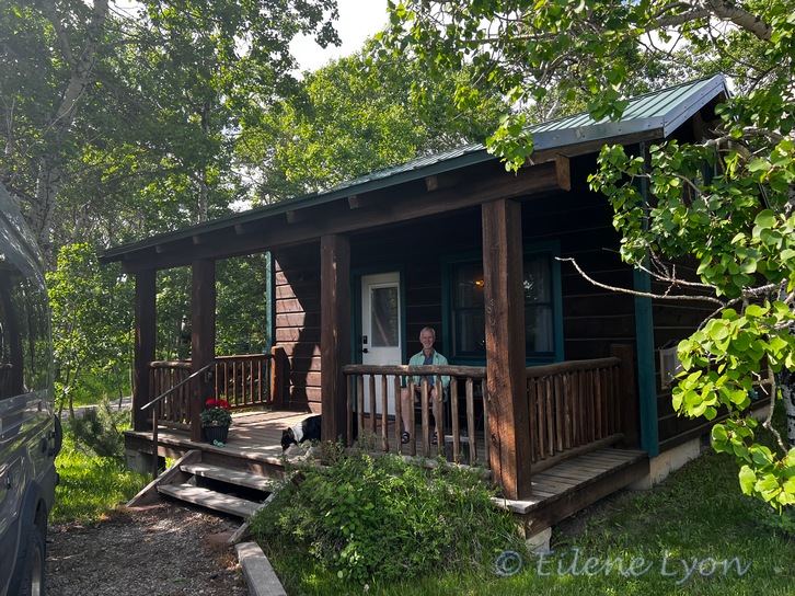
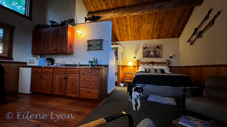
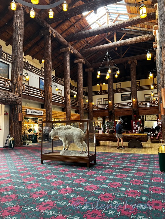
Our final destination before driving up to Canada was East Glacier. Here we stayed in a very nice cabin at Traveler’s Rest and had dinner at Serrano’s Mexican restaurant. We stopped briefly at the beautiful Glacier Park Lodge with its tree trunk construction inside. We skipped the park, having also been there before.
From the lodge, we took a road you don’t see on the big U.S. Road Atlas, even on the Glacier National Park inset: MT 49. Though signs said “No vehicles over 21 feet,” we had no trouble in our 22-foot van with bike rack on the back. I think they really do not want bus-sized RVs or semis. Once we hit US 89 again, we crossed the border into Canada, with little fanfare.
Feature image: The Gates of Lodore on the Green River in Dinosaur National Monument.

What an excellent adventure so far Eilene! The highlights in your photos are spectacular. I’m passing on your posts to the daughter for camping/adventure travels since they love to get off the regular path. She really liked the story about the swifts.
LikeLiked by 1 person
Glad I can inspire people to get off the beaten path. There are plenty of wonders outside our national parks. Of course, in Canada, we headed for the parks!
LikeLiked by 1 person
Having lived my entire life in the Northeast US, I am always stunned by the beauty and immensity of the wide open spaces out west. I haven’t seen much of it—just a drive from Denver to Santa Fe and another drive from Salt Lake City to Jackson, Wyoming and then to Yellowstone. And those are on main highways so not as remote or scenic as your trip. But even so, I was both times struck by the fact that so much of our country is unpopulated or sparsely populated. It is so different here where, unless there is a park or conservation land, everything is developed and heavily populated. It’s like we live in two different countries, and I think that also explains in part the very different perspectives that divide our country’s politics.
LikeLiked by 2 people
Your observations are spot on. The West has so much open space and low population. From the beginning of settlement, the predominant economic driver is resource extraction (including ranching). I like how much open space, relatively unspoiled there is. Then again, at one time, people (natives) were free to roam at will.
LikeLiked by 1 person
Such a spectacularly beautiful part of the world. The reality of what was done to the native peoples as the settlers came through always puts a damper on its history.
LikeLiked by 1 person
Yes, the open spaces came at the expense of displacing the previous inhabitants. Always important to remember.
LikeLiked by 1 person
What a wonderful trip! The images are simply breathtaking.
Like Jane, I am always agrieved when I hear of the plight of the aboriginals.
LikeLiked by 1 person
Yes, we can mourn for the sins of the past. But while some tribes still struggle with the effects of colonialism, others are doing well and reclaiming their heritage. We should always support those efforts.
LikeLiked by 2 people
Yes, absolutely!
LikeLiked by 1 person
🙂
LikeLiked by 1 person
Wow – I have actually been to some of these places! That includes the Beartooth Pass, though we did it the other way from Red Lodge.
LikeLiked by 1 person
Then you have seen spectacular!
LikeLiked by 1 person
What spectacular views you were treated to. I think I’ve been over Beartooth Pass, many years ago. Funny to see snow this time of year.
LikeLiked by 1 person
There was actually a big snowstorm on the pass a week or two after we drove over!
LikeLiked by 1 person
What gorgeous pics!!! Thanks so much for taking us along with you…Looking forward to your Canadian travels 😊
LikeLiked by 1 person
Canada was amazing!
LikeLike
What a trip. I’ve never been to any of these areas and your photos show me that it looks like I think it would. So many places to see along the way, too. Can’t wait to read about the Canada part.
LikeLiked by 1 person
I’m providing the vicarious tour of the Rockies. But really, find time to see for yourself!
LikeLiked by 1 person
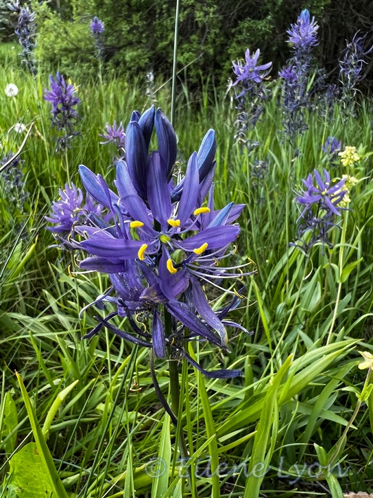
I’m with hunter is that the cabin is spiffy. The scale of the landscape is mind blogging. My parents visited the Rockies nearly 40 years now, and we were intrigued with their trip. What too fascinated me was the Camas and that it was an important food source for the Nez Perce and other Interior Northwest tribes. I need to go find more information. Interesting fodder, thanks Eilene.
LikeLiked by 1 person
Yeah, I could actually be pretty happy in a cabin about like that all the time! The distances are vast and the scenery magnificent. But you have the goods in New Zealand, too. Glad I offered something intriguing for you to research.
LikeLiked by 1 person
We do have sights on a much smaller scale, which I suppose is a bonus as unlike Australia and America there’s not a huge amount of driving. Here we can be on a snowfield and within hours the beach. It was interesting that the indigenous people used the bulbs as a carb to fuel their people. I’m getting over a nasty cold so have plenty of time on my hands 😉
LikeLiked by 1 person
Bummer. I hate colds as much as any illness. Get well soon! Maybe I’ll get as far as NZ someday.😊
LikeLiked by 1 person
I’m sure you won’t regret it 🙂
LikeLiked by 1 person
More scenic eye candy from the famous explorers but I have one question? How do you reckon Canada’s gonna let you outlaws in? 😉
LikeLiked by 1 person
He he he. Well, there was one little hiccup…
LikeLiked by 1 person
Hahahahaha!
LikeLiked by 1 person
Thank you for sharing the wonderful photos of your trip! I can only imagine how stunning those views must be in person.
LikeLiked by 1 person
Photos can never replicate the real thing! Hopefully it entices some to get out and explore.
LikeLiked by 1 person
You’re right about that!
LikeLiked by 1 person
😉
LikeLiked by 1 person
This leg of your trip was beautiful and I will look forward to the Canadian portion as well. I liked Jarvie’s trading post – very authentic and fun at the same time. The Traveler’s Rest cabin looked so rustic and quite small at first glance. I was surprised how modern and large it was. That’s good you had no issues crossing the border into Canada.
LikeLiked by 1 person
Thank you Linda. It was a very nice—and apparently new—cabin. I could live like that!
LikeLiked by 1 person
I could certainly live like that too Eilene – away from the hustle and bustle of city life and such a scenic place.
LikeLiked by 1 person
I’ve lived in big cities, but have been rural for 40 years. I do not miss the city!
LikeLiked by 1 person
I don’t blame you Eilene!
LikeLiked by 1 person
Fun and great pics!!!
LikeLiked by 1 person
Thanks, LA!
LikeLiked by 1 person
I’m so excited you did this trip without interstate! There’s a whole world beyond that paved jungle and that’s where things get really interesting. I love the west for its wide open spaces and your pictures make me wish for a return trip.
LikeLiked by 1 person
I get that the interstates have been a good way to move people and goods, but I will always prefer the slower roads and the places they take you. Freeway exits are pretty homogeneous.
LikeLiked by 1 person
Agreed. Although freeways are great if you’re practicing for the Saturday night races!
LikeLiked by 1 person
Nice trip and itinerary! Welcome to Canada!
LikeLiked by 2 people
Thanks, Joni!
LikeLiked by 1 person