Week 38: #52 Ancestors – On the Map
By Eilene Lyon
I confess to being a bit of a map geek. I even minored in Geographic Information Systems (GIS) when I attended Fort Lewis College in 2004-7. Maps are excellent for visualizing the context of events in our family history. They can help us understand the juxtaposition of our ancestors, their friends (or foes), and neighbors.
I found this 1847 map in a deed book at the Blackford County courthouse in Hartford City, Indiana.1 My Ransom ancestors lived in the town known as Trenton, seven miles due east of Hartford City.
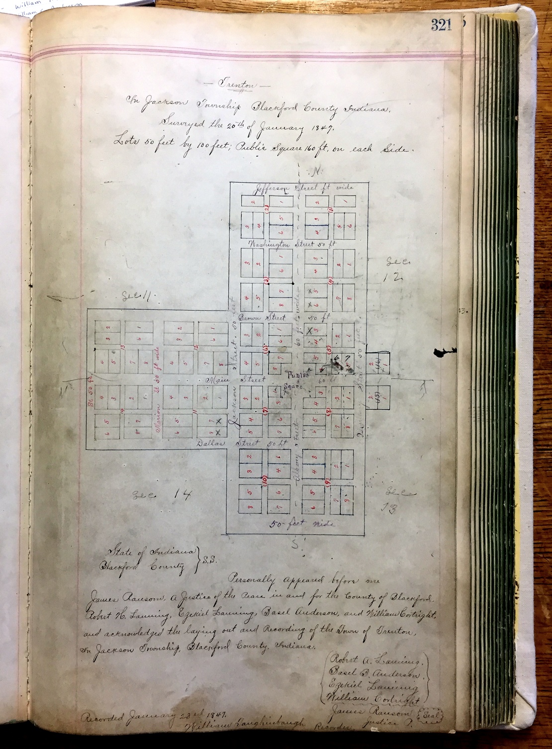
James Ransom (my 3rd great-grandfather) served as a justice of the peace for Jackson Township and in that capacity authenticated this map with his signature (on the original, not this recorded copy). He owned property adjacent to the town as laid out here, but not within the bounds.
Other names on this document of interest to me are: Basel B. Anderson (James Ransom’s brother-in-law) and William Taughinbaugh. Taughinbaugh held a record four positions in the county government. He served as county clerk for many years.2 His son, Franklin Taughinbaugh, went to California with James’s sons, Robert and William Ransom.
Robert H. Lanning, Ezekiel Lanning, and William Cortright held the original patents for the parcels surrounding the crossroads, and were partners with Basel Anderson in laying out the town.3 Robert Lanning once sued James Ransom for slander, winning a sizeable judgment. Two of Cortright’s sons went on the California trip with the Ransoms.
As you can see from the plat, the crossroads sat at the corner of Sections 11, 12, 13, and 14 of Jackson Township. There are five named streets running east-west, centered on Main Street. Four named streets run north-south, plus border streets and alleys. It looks like a nice, regular little town.
This is what the area looks like today per Google Earth:
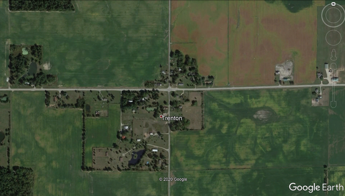
A picture tells a thousand words. There is no town at this crossroads. A few residential lots, two (yes, two!) cemeteries, and surrounding farmland. There are no storefront businesses, and Google didn’t bother doing a Streetview, though you can find nearby Pennville has been done.
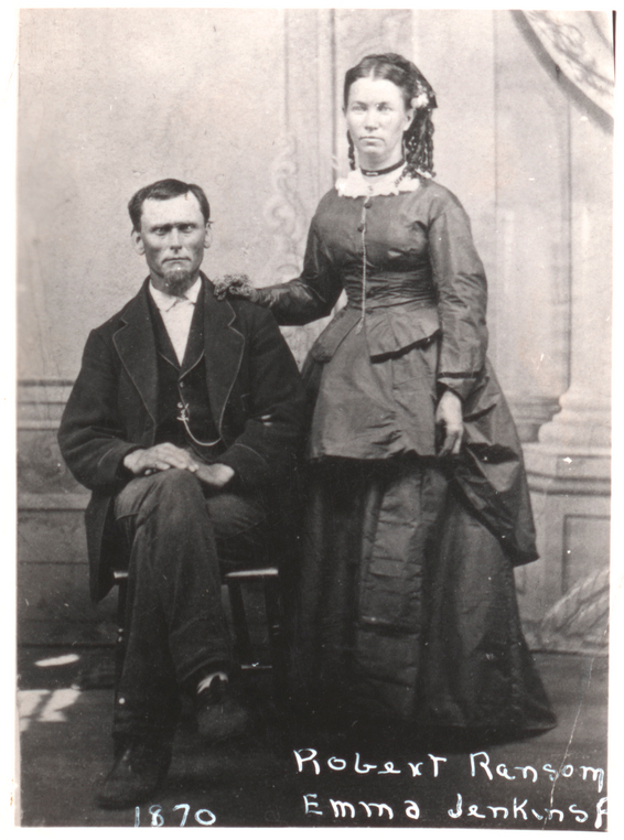
I would really love to see some interim maps that might tell the story of how Trenton grew and eventually declined. I know that it did grow, because James Ransom’s son, Robert (2nd great-grandfather), established a store and several other businesses there in the 1850s and 1860s, after returning from his California gold rush adventure.4 He also served as the first postmaster.5
In 1860, Robert’s brother, Basil, worked as a merchant, and there was also a shoemaker, carpenter, physician and blacksmith in or near the town.6 A decade later, Trenton had two blacksmiths and two millers, a merchant, physician, wheelwright, cooper, carpenter, plasterer, teamster and shoemaker. Robert’s occupation is given as “Dealer in Davison.”7 (I have no idea.)
The post office closed in 1907.8 By the time the 1940 census rolled around, Trenton was not even a named place in the Jackson Township enumeration. Only Millgrove earned that distinction.9 Neither place is considered a town today, but you can still find them…on the map.
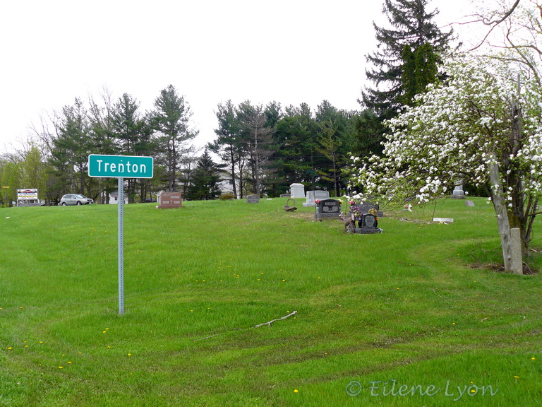
Feature image: You would never know that you were driving through Trenton, Indiana, unless you noticed this sign on Highway 26. (E. Lyon 2017)
- Blackford County Deed Book B, p. 321.↩
- The Biographical and Historical Record of Jay and Blackford Counties, Indiana. 1887. Lewis Publishing Company, Chicago, p. 728-9.↩
- https://glorecords.blm.gov/ ↩
- Family letters and notes.↩
- Record of Appointment of Postmasters, 1832-1971. NARA Microfilm Publication, M841, 145 rolls. Records of the Post Office Department, Record Group Number 28. Washington, D.C.: National Archives – via Ancestry.com.↩
- Year: 1860; Census Place: Jackson, Blackford, Indiana; Page: 633; Family History Library Film: 803245 – via Ancestry.com.↩
- Year: 1870; Census Place: Jackson, Blackford, Indiana; Roll: M593_300; Page: 402B; Family History Library Film: 545799 – via Ancestry.com.↩
- https://en.wikipedia.org/wiki/Trenton,_Indiana ↩
- 1940 U.S. Federal Census for Jackson Township, Blackford County, Indiana – via Ancestry.com.↩

I find the rise and fall of places totally fascinating (you might want to grab a few pics of nyc just in case) but seriously, I would love to see a timeline of the photos. So interesting
LikeLiked by 1 person
Blackford is one of the poorest counties (and smallest) in Indiana. Even Hartford City doesn’t have many businesses today. It seems like an attractive area, but maybe I was there at a good time. Hard to say why some places fail to thrive. It does make me wonder.
LikeLiked by 1 person
Now you’ve got me thinking
LikeLiked by 1 person
I expect it can be difficult for rural areas to reach some critical mass of people that will sustain growth. If it doesn’t happen, the cause gets abandoned.
LikeLiked by 1 person
Highways, trains, buildings, weather…so many outside influences
LikeLiked by 1 person
Very true. Lots of places got bypassed by transportation networks – lacked the political influence.
LikeLiked by 1 person
It’s interesting how a town is born, grows up and then one day it just starts to wither away due to economic reasons. We have a ton of river towns in this state whose glory days seemed to have no end, until they did.
LikeLiked by 1 person
I visited a couple gold rush towns in Montana recently (one still viable as a tourist stop, the other now a state park). When those decline, given the location, it’s understandable. Others are difficult to fathom. I think when enterprising people like Robert Ransom leave a place, the energy vacuum doesn’t necessarily get filled.
LikeLiked by 1 person
So true
LikeLiked by 1 person
I agree with your other commenters in finding the demise of small towns fascinating. In northern New England, it seems to be due to loss of farms when the land played out from bad farming practices (19th century) and mills closing down (20th century).
LikeLiked by 1 person
All boils down to economics. I think some places have citizens who are creative, progressive thinkers who mold their circumstances and others tend to prefer the status quo and circumstances rule. The latter get left behind.
LikeLiked by 1 person
You are so right about that. That was very much the mindset of small towns in northern Vermont when I was growing up. The status quo meant don’t allow any new businesses to come in–and then wonder why all the talented young people leave.
LikeLiked by 1 person
I think that might be a sad reality in many places. In some ways I don’t like to see growth and change, either. But I wouldn’t want my town to wither and die.
LikeLike
Wow! Imagine collecting images from a variety of maps over time and then flipping through them like one of those flip books where it all seems in motion. I also would love to do that for my ancestors. I’m fascinated by the places where they lived.
LikeLiked by 1 person
Wouldn’t that be a hoot. In the future, family historians will be able to do that with archived satellite images. Pretty cool!
LikeLike
It would amazing!
LikeLiked by 1 person
The rise and fall of towns is truly interesting – I’ve visited a couple ghost towns over the years and always found them chilling! I also hear ya about old maps. I have a ton of old battlefield maps 🙂
LikeLiked by 1 person
I can stare at maps endlessly 🧐 I never fail to learn something. It seems I’m not alone in my curiosity about why certain communities live or die.
LikeLiked by 1 person
“Dealer in Davison”? That’d make a great blog name. I wonder, though, what that means? Businessman or card shark? It could be either.
LikeLiked by 1 person
Hahaha! No way The Preacher Man would be dealing cards. I expect Davison (or Davidson) was some type of farming equipment manufacturer, but my internet searches turned up nothing. My great-grandmother indicated he manufactured bricks and ax handles. Who knows? He was a successful businessman until he and his brother bought a bank and got involved in shady real estate investing. Well, we would call it shady now, but was all perfectly legal then.
LikeLiked by 1 person
When I saw the title, I thought of Trenton, New Jersey! Such a different place with an entirely different history. Fascinating post, Eilene. I love maps also, but have never studied such an old map. It’s incredible what you were able to figure out from this.
LikeLiked by 1 person
Thanks, Amy. It’s just a small piece of a large amount of research for my gold rush book, so many sources contributed. It was a bit of a surprise to me, having been to Trenton, that they had laid out such an extensive town. I still wonder if any of those streets ever existed.
LikeLiked by 1 person
Hey, I love maps too! In fact, I used to be the chief map-reader for our family when we traveled. I think my parents encouraged me so I’d stop asking, “are we there yet?”
Great story you wove together, Eilene!
LikeLiked by 1 person
I knew you must have smart parents! I still rely on gazetteers when we travel, because they show all the roads and trails and campgrounds that don’t show up on Google maps or regular road atlases.
LikeLiked by 1 person